Tokyo to Shimoda: The Ultimate Izu Peninsula Coastal Drive — Hot Springs, Ocean Cliffs & Scenic Roads
There are road trips, and then there are experiences. The drive from Tokyo down the Izu Peninsula to Shimoda is firmly in the second category. Picture this: volcanic cliffs plunging into the Pacific, a ridge road with Mt. Fuji floating above the clouds on one side and the endless blue ocean on the other, steaming hot spring towns tucked into hillsides, and one of Japan’s most dramatic suspension bridges swaying above crashing waves. This is a route that rewards drivers — and it’s one of the most underrated coastal drives in all of Japan.
What makes this route truly special is its variety. Within roughly 150 kilometers south of Tokyo, the landscape transforms completely — from the urban buzz of the city to dramatic coastline, volcanic geology, historic resort towns, and finally a sun-soaked southern tip of the peninsula that feels almost Mediterranean. The roads are well-maintained, the signage is manageable even for international visitors, and the payoff at every stop is genuinely spectacular. This isn’t a route you rush through. It’s one you savor.
The whole adventure kicks off right in the heart of Tokyo. You’ll pick up your wheels in Shibuya, where you can grab your rental car and hit the expressway heading south toward the coast. Within an hour, the cityscape starts giving way to mountains and sea, and you’ll wonder why you ever considered taking the train. Let’s break down everything you need to know to drive this route like a local.
Route Overview
This route covers approximately 150 km of driving from central Tokyo to the southern tip of the Izu Peninsula. Here’s the full sequence with estimated driving times between each stop (not including stops or exploration time):
- Pick up your rental car at Samurai Car Japan in Shibuya, Tokyo
- Shibuya → Atami — approx. 90 minutes via the Tomei Expressway and Route 135
- Atami → Izu Skyline (toll road) — approx. 30 minutes up into the mountain ridge
- Izu Skyline → Jogasaki Coast — approx. 40 minutes back down to the coast
- Jogasaki Coast → Kawazu — approx. 30 minutes south along Route 135
- Kawazu → Shimoda — approx. 25 minutes to the southern tip
Total estimated driving time: 3.5–4 hours (without stops). Plan for a full day or ideally an overnight stay to do it justice.
🗺️ Open This Route in Google Maps
Opens in Google Maps app on mobile
Stop 1: Atami — Japan’s Original Hot Spring Resort Town
What to See and Do
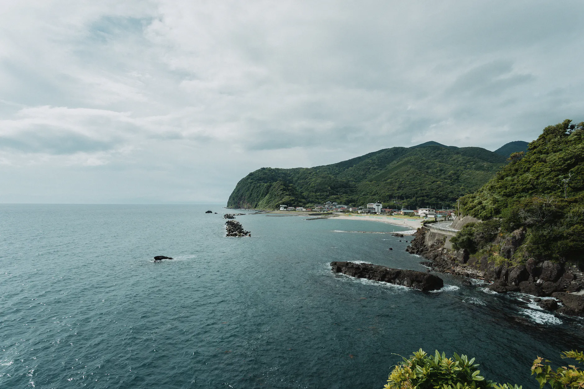
Atami has been Japan’s go-to hot spring escape from Tokyo for well over a century, and it earns that reputation every single time. Perched on a steep hillside above Sagami Bay, this compact resort city is dense with history, character, and — most importantly — incredible onsen. The town’s name literally means “hot sea,” and you’ll understand why the moment you arrive: hot spring water bubbles up everywhere, and the ocean glitters below in every direction.
The crown jewel for visiting drivers is Atami Onsen itself. The real treat here is seeking out an open-air bath (rotenburo) overlooking the Pacific. Several of the larger ryokan hotels offer day-use bathing for ¥1,000–¥2,500 per person — no overnight stay required. The Atami Onsen area along the seafront has multiple public and semi-private bath options. After a soaking session with the ocean spread out before you, you’ll feel completely reset. Beyond the baths, don’t miss MOA Museum of Art, which sits dramatically above the town on a wooded hillside with panoramic ocean views and a remarkable collection of Japanese and Asian art. The Atami Sun Beach and the old-school shopping street (Ginza-dori) running through town are also worth a stroll.
How Long to Spend
Allow 2–3 hours minimum. If you plan a proper onsen soak plus lunch, block out half a day.
Driving Tips: Shibuya to Atami
From Shibuya, head onto the Tomei Expressway (E1) heading southwest toward Yokohama and Odawara. Follow signs toward Odawara, then pick up the Odawara-Atsugi Road or continue on E1 to the Izu-Jukan Expressway (E70) heading south toward Atami. Alternatively, take the coastal National Route 135 from Odawara — this is the more scenic option if you’re not in a rush. The highway route takes roughly 80–90 minutes depending on Tokyo traffic (always leave early to beat the city congestion). Toll costs from central Tokyo to Atami via expressway are approximately ¥2,000–¥2,800 one way depending on your exact entry point and route. Have your ETC card or cash ready at the toll booths.
Parking in Atami
Atami has decent paid parking throughout the town. The Atami Station area parking lots are the most centrally located — expect to pay around ¥300–¥500 per hour. There’s also a larger public parking lot near the Sun Beach waterfront that’s convenient if you want to walk the seafront. On weekends and holidays, the town gets busy, so arrive before 10am to secure a good spot.
Stop 2: Izu Skyline — The Best Driving Road You’ve Never Heard Of
What to See and Do
If you’re a driver, this is your happy place. The Izu Skyline is a 40-kilometer toll road that runs along the spine of the Izu Peninsula’s mountain ridge, connecting the area above Atami in the north to Amagi Pass in the south. On a clear day — and this is not an exaggeration — you can see Mt. Fuji rising majestically to the northwest while simultaneously looking east and south over the vast blue Pacific Ocean. It’s the kind of view that makes you want to pull over every five minutes, which is exactly what you should do.
The road itself is a driver’s delight: smooth tarmac, sweeping curves, minimal traffic on most days, and a series of well-placed pullout areas and observation decks. The Izu Skyline Ichikokyu Parking Area near the northern entrance is a great first stop for photos. Further south, several unmarked pullouts offer even more dramatic views. The road passes through volcanic highland terrain with scrubby trees and open grass slopes — it has a raw, elemental feel that’s quite different from the lush coast below.
How Long to Spend
Plan 1–1.5 hours to drive the full length at a relaxed pace with photo stops. You can also just do the northern section from Atami and drop back down toward the coast near Ito City, which takes about 30–40 minutes.
Driving Tips: Atami to Izu Skyline
From central Atami, follow signs toward Atami Toll Road heading south/inland. The Izu Skyline northern entrance (Atami-Toge IC) is about 15–20 minutes from the center of Atami. The road climbs steeply from sea level up into the mountains — your ears may pop! The toll for the full Izu Skyline is approximately ¥730–¥1,010 for a standard passenger car depending on how much of the road you use. It’s well worth every yen. Speed limits are posted at 60 km/h in most sections, but the curves and views mean you’ll naturally want to go slower.
Parking on the Izu Skyline
There are multiple designated pullout areas and small parking bays along the route — no parking fees within the road itself. The main Ichikokyu rest area near the northern end has a small parking lot and basic facilities.
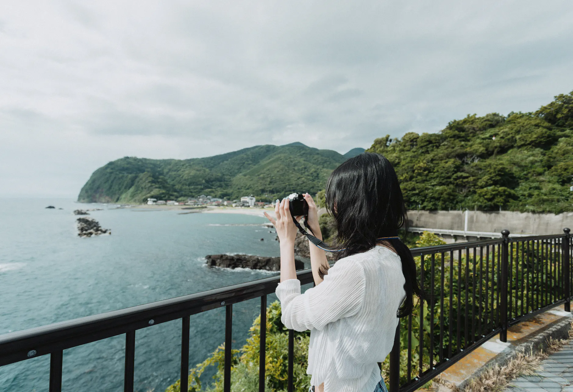
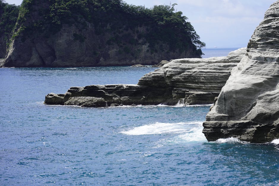
Stop 3: Jogasaki Coast — Volcanic Cliffs and the World’s Most Dramatic Suspension Bridge
What to See and Do
If Atami is the elegant, sophisticated stop on this route, Jogasaki Coast is the raw, adrenaline-pumping one. This stretch of coastline was formed roughly 4,000 years ago when lava from Mount Omuro flowed into the sea, creating a jagged, dramatic cliff line that stretches for nearly 10 kilometers. The result is one of the most visually striking coastlines in Japan — sheer black volcanic rock, sea caves, blowholes, and crashing Pacific waves all combining into something that feels almost prehistoric.
The absolute highlight is the Jogasaki Suspension Bridge (Kadowakizaki Suspension Bridge), a 48-meter-long bridge that spans a gorge in the volcanic cliffs 23 meters above the churning sea below. Walking across it while the bridge sways gently and waves crash against the rocks beneath you is a genuinely thrilling experience. The views from the bridge back toward the cliffs are stunning in both directions. Access to the bridge is via a well-maintained coastal trail — allow about 20 minutes of walking from the nearest parking area. There’s also a lighthouse (Jogasaki Lighthouse) a short walk away that offers elevated views of the entire coastline.
How Long to Spend
Allow 2–3 hours for the coastal trail, suspension bridge, and lighthouse. Wear comfortable walking shoes — the paths are well-maintained but rocky in sections.
Driving Tips: Izu Skyline to Jogasaki
Drop down from the Izu Skyline via the exit near Ito City, then follow National Route 135 south along the coast toward Futo and then Jogasaki. The coastal road here is genuinely beautiful — narrow in sections with the ocean appearing and disappearing between headlands. From the Izu Skyline southern exit, Jogasaki is about 25–35 minutes. Look for signage to Jogasaki Kaigan (城ヶ崎海岸) — it’s well-signposted from Route 135.
Parking at Jogasaki
There are two main parking areas for Jogasaki Coast. The Kadowakizaki Parking Area near the suspension bridge trailhead is the most popular — it costs around ¥500 per vehicle and fills up fast on weekends. There’s also a slightly larger parking area near the Picnic Land entrance further along. Arrive before 9am on weekends to guarantee a spot. On weekdays, parking is rarely an issue.
Stop 4: Kawazu — Cherry Blossoms, Waterfalls, and Riverside Walks
What to See and Do
Kawazu is a small town with an outsized reputation, and for good reason. It’s home to the Kawazu Zakura, a unique variety of cherry blossom tree that blooms earlier than any other variety in Japan — typically from late January through February, well before the famous Tokyo cherry blossoms. The Kawazu Cherry Blossom Festival during this period draws huge crowds, but the riverside setting with hundreds of pink cherry trees lining the Kawazu River is genuinely magical, especially with the ocean visible in the distance and warm yellow rapeseed flowers filling the riverbanks.
Outside cherry blossom season, Kawazu is still worth a stop for its series of seven waterfalls (Kawazu Nanadaru), accessible via a forested gorge trail about 10 minutes inland from the town center. The falls range from delicate curtains of water to thundering cascades, and the trail is a beautiful contrast to the coastal scenery of the rest of the route. There are also several good onsen facilities in and around the town, making it an excellent place to stop for a soak if you didn’t get your fill in Atami.
How Long to Spend
Allow 1.5–2 hours for the riverside walk and one set of waterfalls. During cherry blossom season, block out half a day.
Driving Tips: Jogasaki to Kawazu
From Jogasaki, continue south on Route 135 — one of the most enjoyable stretches of the entire drive. The road hugs the coastline closely here, with the Pacific appearing on your left around every other bend. Occasionally the road dips through small fishing villages where you’ll want to slow down and take it all in. The drive to Kawazu takes about 25–35 minutes from Jogasaki. Entering the town, follow signs to Kawazu-cho and then to the riverside parking areas.
Parking in Kawazu
During cherry blossom season, Kawazu operates large temporary parking areas on the outskirts of town with shuttle buses running to the river — fees are typically ¥500 per vehicle. Outside festival season, there are several smaller free and paid parking lots near the river walk, most charging around ¥200–¥300 per hour.
Stop 5: Shimoda — Where Japan Met the World
What to See and Do
Shimoda is the perfect final destination for this drive: a laid-back, sun-soaked port town at the southern tip of the Izu Peninsula with a fascinating history, beautiful beaches, and an easy-going vibe that makes you want to stay longer than you planned. This is where Commodore Matthew Perry of the U.S. Navy anchored his “Black Ships” in 1854, effectively forcing Japan to open its borders after over two centuries of isolation. That history is woven into everything here, from the famous Perry Road — a photogenic stone-paved lane lined with old willow trees and historic buildings — to the various museums and temples that commemorate the event.
For beach lovers, Shimoda Beach (specifically Shirahama Beach a few kilometers west of town) is one of the finest stretches of white sand in the entire Izu Peninsula, with remarkably clear water that turns brilliant blue-green in summer. The town beach area is walkable from Perry Road and the historic center. Back in town, the Ryosenji Temple — where the Convention of Kanagawa was signed — is a must-visit, and the narrow streets of the old town have a wonderful collection of small cafes, craft shops, and seafood restaurants.
How Long to Spend
If you can swing it, stay overnight in Shimoda. There are excellent guesthouses and small hotels around the port. If it’s a day trip, allow 3–4 hours to cover the beach, Perry Road, and at least one temple or museum.
Driving Tips: Kawazu to Shimoda
The final leg from Kawazu to Shimoda continues on Route 135 south — a beautiful 25-minute drive that follows the coastline almost continuously. As you get closer to Shimoda, the peninsula narrows and the scenery becomes more dramatic with steep hills and rocky outcrops. The road into Shimoda passes through a short tunnel before opening up to the harbor view. The town itself has a one-way traffic system in some areas, so follow the navigation carefully.
Parking in Shimoda
Shimoda has several well-organized parking lots near the station and the harbor area. The Shimoda Port Parking near the ferry terminal is the most convenient — fees are around ¥300–¥500 per hour or flat rates for the full day. There’s also paid parking near the Perry Road entrance. On summer weekends the town gets busy, but parking is generally easier here than in Atami.
Driving Tips for the Izu Peninsula Route
Road Conditions
The roads on this route are generally in excellent condition. Route 135 along the coast is a well-maintained national highway, though it narrows to one lane in each direction through some villages. The Izu Skyline is a private toll road kept in pristine condition. Mountain roads inland can be narrow with tight hairpins — take them slowly and watch for vehicles coming the other way.
Best Time of Day to Drive
Leave Shibuya before 7:30am on weekdays, or before 6:30am on weekends, to beat Tokyo’s notoriously heavy outbound traffic. This will also mean you arrive at Atami before the day-trippers and have your pick of parking spots throughout the route.
Fuel Stations
Fuel is readily available along Route 135 through most towns. Fill up in Atami or Ito before heading onto the Izu Skyline, as there are no fuel stations on the toll road itself. Eneos, Shell, and Cosmo are the most common chains in the area. Expect to pay around ¥170–¥185 per liter for regular unleaded (レギュラー).
Toll Summary
- Tomei Expressway (Tokyo to Odawara area): approx. ¥1,500–¥2,000
- Izu-Jukan Expressway sections: approx. ¥500–¥700
- Izu Skyline (full length): approx. ¥730–¥1,010
- Total estimated tolls for the full route: ¥3,000–¥4,000 one way
An ETC card (electronic toll card) is strongly recommended — it works in all toll lanes and is often cheaper than cash at certain times. Ask your rental car company about ETC card options when you pick up the car.
International Driving Permit (IDP)
Foreign visitors driving in Japan must carry a valid International Driving Permit (IDP) along with their home country driver’s license. Japan accepts IDPs based on the 1949 Geneva Convention — check which type your country issues. Note that licenses from certain countries (including Switzerland, Germany, France, Belgium, Monaco, and Taiwan) may have different arrangements. Apply for your IDP in your home country before departure — they cannot be obtained in Japan.
Where to Eat Along the Route
In Atami
- Atami Ginza Shopping Street: Several seafood restaurants and izakaya line this pedestrian strip — look for fresh kinmedai (splendid alfonsino), a local specialty that’s caught just offshore.
- Korakuen (Hotel Restaurant): Day-use onsen packages here often include a kaiseki lunch with ocean views — exceptional value for the experience.
- Street food stalls near Sun Beach: Try the local taiyaki and grilled seafood skewers from the small stalls that line the beach promenade.
Near Jogasaki Coast
- Futo Fishing Port area: Just before Jogasaki, the small port town of Futo has a handful of fantastic seafood restaurants. The catch is landed here daily — the sashimi sets are outstanding and very reasonably priced at around ¥1,500–¥2,500.
In Kawazu
- Riverside food stalls (during blossom season): During the cherry blossom festival, vendors line the river selling local produce, wasabi ice cream, and grilled corn.
- Wasabi cuisine: Kawazu and the broader Izu region are famous for fresh wasabi. Several restaurants in town serve wasabi-infused dishes — try the wasabi don (rice bowl) at local lunch spots near the river.
In Shimoda
- Gorosaya: Consistently one of the best seafood restaurants in Shimoda, known for its fresh local fish and the stunning visual presentation of its sashimi platters. Expect queues on weekends — arrive at opening time (usually 11am for lunch).
- Perry Road cafes: Several small cafes line Perry Road offering coffee and light meals in beautifully preserved historic buildings. Great for an afternoon break.
- Port-side izakaya: Come evening, the streets around Shimoda Port come alive with small izakaya serving local kinme fish dishes and cold Izu craft beer. Walk and explore — there are several excellent options with no reservations needed.
Best Season for This Drive
Spring (February–April) ⭐ Highly Recommended
Late January through February is cherry blossom season in Kawazu — the earliest in Japan. March and April bring pleasant temperatures (12–18°C), clear skies, and lush spring greenery throughout the peninsula. Traffic can be heavy during peak blossom weeks but the scenery is unforgettable. The Izu Skyline is typically clear and in excellent condition from March onward.
Summer (June–August) — Great for Beaches, Be Aware of Crowds
Summer is beach season along this route. Shimoda’s Shirahama Beach is at its best, and the coastal road is at its most vibrant. However, July and August are Japan’s peak domestic travel season — expect higher accommodation prices, crowded beaches, and weekend traffic jams on Route 135. The rainy season (tsuyu) runs roughly June–mid July, so plan accordingly.
Autumn (September–November) ⭐ Highly Recommended
Arguably the best season for this drive. The summer crowds have gone, temperatures are perfect for driving with the windows down (18–25°C), the sea is still warm enough to enjoy, and the autumn colors in the Izu highlands add a gorgeous layer to the Izu Skyline drive. This is our top recommendation for first-time visitors who want the best of everything.
Winter (December–February) — Peaceful but Cooler
The Izu Peninsula is warmer than most of Japan in winter thanks to the Kuroshio Current warming the coast. It’s a wonderful time for onsen visits, and the winter light is crystal clear — often giving the best Mt. Fuji views from the Izu Skyline. Just check road conditions before using the Skyline in December–January as frost and occasional ice can occur.
Frequently Asked Questions
Where can I rent a car for this route?
The most convenient starting point is Samurai Car Japan in Shibuya, Tokyo. It’s perfectly positioned for heading straight out of the city onto the Tomei Expressway toward Atami. They offer self-drive rentals as well as guided JDM tours — it’s a great option especially if you want a bit of help with route planning or want to experience the route in something a bit more exciting than a standard economy car.
Do I need an International Driving Permit (IDP) to drive in Japan?
Yes, absolutely. An International Driving Permit based on the 1949 Geneva Convention is required for most foreign nationals driving in Japan. You must obtain this in your home country before departing — it cannot be issued in Japan. Carry both your IDP and your original home country driver’s license with you at all times while driving.
How long does the full route take?
Driving time alone is approximately 3.5–4 hours from Shibuya to Shimoda. With proper stops at all the highlights — onsen in Atami, the Izu Skyline drive, Jogasaki suspension bridge walk, Kawazu riverside, and Shimoda exploration — you realistically need a full day. We strongly recommend spending at least one night in Shimoda or along the route to fully enjoy it without rushing.
Is the Izu Skyline open year-round?
The Izu Skyline is generally open year-round but is subject to temporary closures due to fog, heavy rain, high winds, or icy conditions — most commonly in winter and during typhoon season (August–October). Check the NEXCO Central Japan website or call the Izu Skyline management office before your trip if weather conditions are uncertain.
Can I do this route as a day trip from Tokyo?
Technically yes, but it will feel rushed. If you leave Shibuya by 6:30am and drive straight back from Shimoda by 5pm, you can fit in the highlights — but you’ll be sacrificing depth for speed. Far better is to plan an overnight stay in Shimoda or Kawazu, which lets you enjoy the southern end of the route properly and drive back the next morning at a relaxed pace. The morning light on the return drive along Route 135 is spectacular.
Why not elevate your journey with a legendary JDM experience?

Our Services:
- Self-Drive Rentals
- Guided Tours
- Drift Experiences
Please visit the dedicated page for more details.
Book a Hot Spring Day Trip
Escape Tokyo and relax in Hakone's famous hot springs. Includes transport, scenic views of Mt. Fuji, and onsen access. Free cancellation.
Related Articles
- Mt Fuji Climbing Guide: Routes, Gear and When to Go
- Hakone Hot Spring Day Trip from Tokyo
- Mt Fuji Day Trip from Tokyo
fuji tour
The Ultimate JDM Road Trip: 1-Day Mt. Fuji & Fuji Speedway Itinerary
Are you ready to experience Japan's most iconic landscapes from the driver's seat of a legendary sports car like the Nissan Skyline?
This one-day self-drive itinerary offers the perfect blend of traditional Japanese beauty and pure motorsport adrenaline. Starting with the world-famous views around the Fuji Five Lakes and culminating at the holy grail of Japanese motorsports—Fuji Speedway—this route is tailor-made for car enthusiasts.
📍 Tour Overview
- Total Duration: Approx. 8-9 hours
- Starting Point: Tokyo or Gotemba area (heading towards Yamanashi)
- Vehicle of Choice: Nissan Skyline (or your favorite JDM sports car!)
🕒 Recommended Itinerary
08:30 | Arakurayama Sengen Park (1 Hour)
Kick off the day with a postcard-perfect view. Beat the crowds by arriving early. After climbing the 398 steps to the observation deck, you will be rewarded with the world-famous view of the five-story Chureito Pagoda framing Mt. Fuji. The crisp morning air and the soft morning light make this the absolute best time for photography.
- Pro-tip: Wear comfortable walking shoes for the stairs!
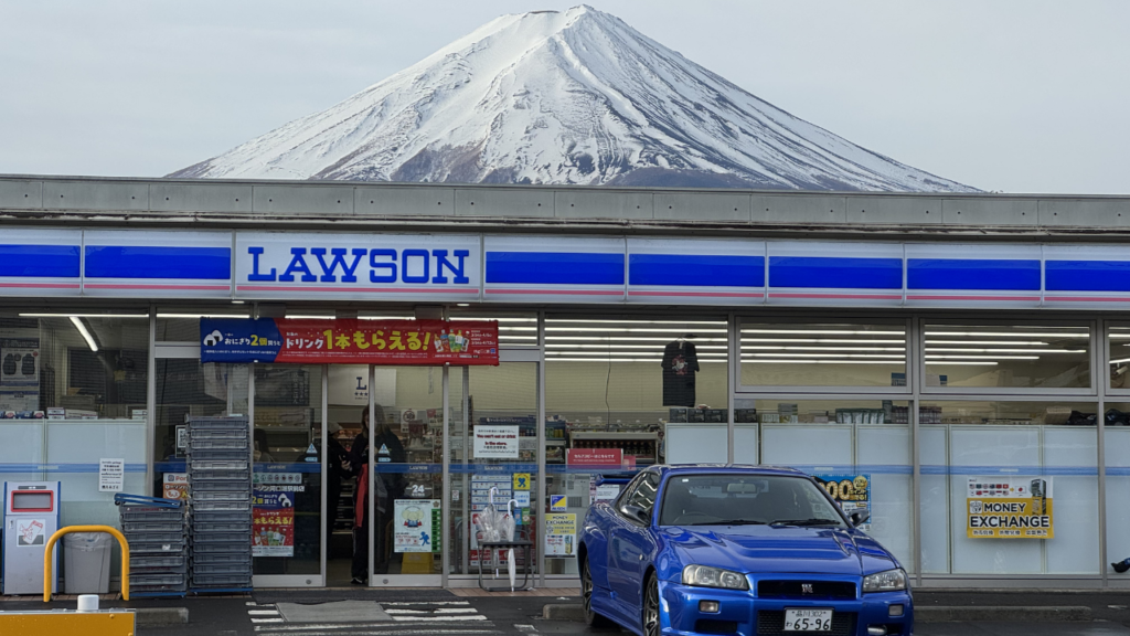
09:45 | Lawson Kawaguchiko Station (15 Mins)
The viral photo spot. Just a short drive away is the famous "Mt. Fuji Lawson." It’s an incredibly popular spot on social media where the massive mountain looms directly over the convenience store roof. Park your Skyline safely in the designated area, grab a canned coffee, and snap a quick photo.
- Driver's Etiquette: This area gets extremely busy. Please respect local traffic rules, avoid parking on the street, and watch out for pedestrians.
10:15 | Lake Kawaguchi & Oishi Park (1 Hour)
Scenic cruising and lakeside photos. Cruise along the northern coast of Lake Kawaguchi. The winding lakeside roads are a joy to drive in a sports car. Stop by Oishi Park, where you can capture stunning photos of your car with the lake and Mt. Fuji in the background, surrounded by seasonal flowers.
11:45 | Oshino Hakkai (1.5 Hours)
Crystal clear springs and local street food. About a 30-minute drive from the lake brings you to Oshino Hakkai, a traditional village famous for its eight sacred ponds fed by Mt. Fuji's melting snow. The water is so clear you can see straight to the bottom. This is the perfect pit stop for lunch. Enjoy freshly made Soba noodles, grilled river fish, or toasted Kusamochi (sweet mugwort rice cakes) from the local vendors.
14:00 | Fuji Speedway / FSW (2 Hours)
The climax for motorsport fans. After a thrilling drive through the scenic mountain passes of Route 138, you will arrive at Fuji Speedway in Shizuoka. Depending on the day’s schedule, there are two epic ways to enjoy this holy ground:
- Experience Run (Drive the track!): On select days, you can actually drive your own Skyline on the international racing circuit behind a pace car (no helmet required!). It's an unforgettable experience to feel the same tarmac as racing legends.
- Fuji Motorsports Museum: Located at the adjacent hotel, this museum showcases about 40 historic racing cars from various global manufacturers. It’s a deep dive into the history of speed.
🇯🇵 Plan Your Japan Experience
JDM Car Rental
Drive a GT-R, Supra, RX-7, or Silvia on the roads they were built for. Hakone passes, Wangan highway, mountain touge — your dream JDM experience.
Daikoku PA Tour
Visit Japan's most legendary car meet. Hundreds of modified cars, passionate owners, and the heartbeat of JDM culture. Guided weekend night tours available.
Photo Guide Tour
Capture stunning photos at locations only locals know. Hidden shrines, backstreet alleys, rooftop views, and golden hour spots for unforgettable shots.