The Ultimate Mt. Fuji Photography Drive: Shibuya to the Fuji Five Lakes by Car
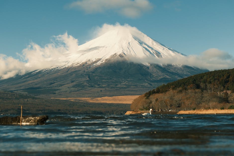
There are road trips, and then there are road trips that make you pull over every ten minutes because you can’t believe what you’re looking at. The drive from Tokyo out to the Fuji Five Lakes is firmly in the second category. From the moment you clear the city and start heading southwest on the expressway, Mt. Fuji begins to dominate the horizon — a snow-capped, perfectly symmetrical cone that honestly looks like someone photoshopped it into the sky. Every bend in the road, every gap in the treeline reveals a new angle, a new reflection, a new reason to reach for your camera.
This particular route threads through four of the five Fuji lakes — Kawaguchiko, Saiko, Shojiko, and Motosu — each one with its own personality and its own jaw-dropping view of Japan’s most iconic mountain. You’ll stop at the pagoda that’s plastered across a million Instagram feeds, hike through a lava forest that feels like another planet, ride a ropeway straight into the clouds, and find yourself standing at the exact viewpoint printed on Japan’s 1,000-yen bill. It doesn’t get more bucket-list than this.
The best part? Doing this route by car turns a good trip into a great one. You move on your own schedule, stop wherever the light looks incredible, and reach viewpoints that tour buses can’t access. Start by heading to Shibuya, where you can pick up your rental car and drive straight onto the Chuo Expressway — no complicated transfers, no waiting for buses. Once you’re out of the city, the road opens up and Mt. Fuji starts calling your name.
Route Overview
This drive covers roughly 120 kilometers from Shibuya to Lake Motosu and is designed as a full-day adventure, though many people stretch it into two days to fully soak in each location. The roads are excellent throughout — a mix of expressway, national routes, and smooth lakeside roads. Here’s the full sequence:
- Pick up your rental car at Samurai Car Japan in Shibuya, Tokyo — your road trip begins here
- Shibuya → Lake Kawaguchiko — approx. 90 minutes via Chuo Expressway (E20) — first and most famous Fuji lake
- Lake Kawaguchiko → Chureito Pagoda — approx. 15 minutes drive + 20-minute hike — the iconic photo spot
- Chureito Pagoda → Fuji Panoramic Ropeway — approx. 20 minutes — aerial views of Fuji and the lake below
- Lake Kawaguchiko → Lake Saiko — approx. 20 minutes via Route 139 — quieter lake with lava caves
- Lake Saiko → Aokigahara Forest — approx. 10 minutes — mystical lava forest trail
- Lake Saiko → Lake Shojiko — approx. 15 minutes via Route 139 — smallest and most serene lake
- Lake Shojiko → Lake Motosu — approx. 15 minutes — the 1,000-yen bill viewpoint finale
Total driving time (without stops): approximately 2.5–3 hours
Recommended time with stops: 8–10 hours (full day) or split over 2 days
Expressway tolls (Shibuya to Kawaguchiko area): approximately ¥2,200–¥2,700 one way with ETC card
Fuel estimate (full route): approximately ¥2,500–¥4,000 depending on vehicle
🗺️ Open This Route in Google Maps
Opens in Google Maps app on mobile
Stop 1: Lake Kawaguchiko — The Gateway to Fuji’s Best Views
You’ll know you’ve arrived the moment you crest a hill on the Chuo Expressway and Mt. Fuji fills your entire windshield. It’s genuinely one of those moments that makes you gasp out loud. Lake Kawaguchiko is the largest and most accessible of the Fuji Five Lakes, sitting at around 830 meters above sea level, and on a clear day the reflection of Mt. Fuji on the water is simply unreal.
Leave Shibuya, grab your rental car, and head west on the Chuo Expressway (E20). The drive is smooth and well-signed in English. Exit at Kawaguchiko IC — the toll will run you around ¥1,950–¥2,200 with an ETC card from Shibuya. From the exit it’s less than 10 minutes to the lake’s northern shore. The lakeside road, Route 137, curves beautifully around the water and most of the key viewpoints are right along this stretch.
How long to spend: 2–3 hours minimum at Kawaguchiko, not counting Chureito Pagoda and the Ropeway (both covered below).
Parking: The Kawaguchiko Lakeside Parking Area near the music forest on the north shore offers free parking and is usually the best base for exploring. There’s also paid parking near the ropeway station (¥500–¥700 for the day). During cherry blossom season and autumn, arrive before 8:00 AM — it fills up fast.
The town itself is lovely for a wander — there are souvenir shops, cafes, and a pleasant lakeside promenade. But the big-ticket experiences here are the Chureito Pagoda and the Fuji Panoramic Ropeway, both of which deserve their own sections below.
Stop 2: Chureito Pagoda — The Most Iconic Mt. Fuji Photo in the World
If you’ve ever seen a photo of a red pagoda with Mt. Fuji perfectly framed in the background, you’ve seen Chureito Pagoda. It’s part of the Arakura Sengen Shrine complex in Fujiyoshida, and it is — without question — the single most photographed viewpoint in the entire Fuji Five Lakes area. Getting this shot is a rite of passage.

From the Kawaguchiko lakefront, drive east along Route 137, then north on Route 138 toward Fujiyoshida. The shrine parking area is located at the base of the hill — look for the signs to Arakura Sengen Shrine. Parking here is free, but limited to around 30 spaces. If it’s full (which it often is), there’s overflow parking a short walk further along the road. From the car park, you’ll climb 398 steps up the hillside to reach the pagoda — it takes about 15–20 minutes at a comfortable pace and is worth every step.
How long to spend: Allow 45–60 minutes including the climb and time to compose your shots. During cherry blossom season (late March to early April), the trees lining the staircase burst into pink — this transforms the scene into something almost otherworldly.
Admission: Free to climb the steps and visit the shrine. The pagoda area itself has no entry fee.
Stop 3: Fuji Panoramic Ropeway — Fuji from Above
After the pagoda, drive back toward the lake and follow signs to the Fuji Panoramic Ropeway (Kachi Kachi Yama Ropeway) on the northern shore of Kawaguchiko. It’s a short, easy drive — about 20 minutes from Chureito. Parking at the ropeway station costs around ¥500–¥700.
The ropeway carries you up Mt. Tenjo in about 3 minutes, rising 400 meters above the lake. When the doors open at the top, Mt. Fuji fills the horizon in a way that no photo fully prepares you for. The summit observation deck offers a 360-degree panorama — lake below, Fuji dead ahead, forest stretching to every horizon. On clear days you can see all the way to the Yatsugatake mountain range.
Operating hours: Generally 9:00 AM – 5:20 PM (last ascent), with seasonal variations. Check ahead in winter.
Round-trip fare: Adults ¥1,000, children ¥500
How long to spend: 45–60 minutes including the ride up, time at the summit, and descent.
There’s a cute café and gift shop at the summit — the Tanuki themed decorations throughout the ropeway are a fun quirk based on a local folktale. Grab a coffee, take in the view, and then head back down to your car. It’s time to follow the road west toward the quieter lakes.
Driving this route? We’ve got you covered.
Hundreds of international visitors have driven this route with a car from Samurai Car Japan. Our team will brief you on road conditions, tolls, and the best stops before you set off.
Stop 4: Lake Saiko — Bat Caves, Lava Molds, and Aokigahara Forest
From Kawaguchiko, head west on Route 139 toward Lake Saiko. The drive takes about 20 minutes and the road is scenic the whole way — you’re driving through the forested corridor between the lakes and Fuji’s lower slopes. This stretch has a noticeably wilder feel than the road around Kawaguchiko. Keep your eyes open: on clear days you’ll catch Fuji framed between the trees at several points.
Lake Saiko is the third-largest of the Fuji Five Lakes and feels like a genuine escape from the tourist crowds. It’s a calm, beautiful lake surrounded by forest, and the views of Fuji from the western shore are stunning and far less photographed than Kawaguchiko’s. The Saiko Panorama Platform on the hillside north of the lake is worth the short detour — it gives you a sweeping elevated view over the lake with Fuji as the backdrop.
Parking: There’s a free public parking area on the south shore of the lake near the camping area. It can hold around 50 cars comfortably.
Saiko Bat Cave (Komori Ana)
One of the strangest and most memorable stops on this entire route is the Saiko Bat Cave, a volcanic lava tube that was formed during one of Fuji’s ancient eruptions. It’s only a short drive from the lake’s south shore, and there’s dedicated parking right outside (free). The cave stays at around 3°C year-round, so bring a layer even in summer. You can rent hard hats and torches at the entrance for a small fee. Inside, the cave winds through jagged lava formations — it’s dimly lit, slightly claustrophobic in places, and genuinely atmospheric.
Entry fee: ¥350 adults, ¥200 children
How long: About 30–40 minutes for the full walk-through
Aokigahara Forest — Hiking Through a Lava Wilderness
Just south of Lake Saiko, stretching across the lower slopes of Mt. Fuji, is Aokigahara — a vast, ancient lava forest that is genuinely unlike anywhere else on earth. The forest grew directly over a massive lava field from Fuji’s 864 AD eruption, and the result is a landscape of extraordinary strangeness: trees growing out of cracked lava, roots wrapping around boulders, and a dense canopy so thick that it’s dark even at midday.
The forest has a somewhat infamous reputation, but the hiking trails — particularly the Lava Tree Molds Trail (Jukai Lava Tree Mold) — are perfectly safe, well-marked, and genuinely spectacular for nature photography. The lava tree molds are hollow vertical shafts in the ground where ancient trees were engulfed by lava; the trees burned away and left perfect cylindrical voids in the rock. It’s eerie and fascinating in equal measure.
Parking: Free parking lot at the Lava Tree Mold entrance on Route 71, near the Aokigahara parking area.
Hiking time: The main lava mold loop is about 1 hour at a relaxed pace.
Stop 5: Lake Shojiko — The Smallest, the Quietest, the Most Serene
From Lake Saiko, continue west on Route 139 and then branch south onto Route 300 toward Lake Shojiko. The drive takes about 15 minutes and the road becomes noticeably quieter — you’ll feel like you’ve genuinely escaped the tourist trail. Lake Shojiko is the smallest of the Fuji Five Lakes, and that intimacy is its greatest charm.
Pull over anywhere along the south shore and you’ll be rewarded with views of Mt. Fuji that feel almost personal — the mountain looms large over the treeline and the reflections on the still water have a painterly quality. There’s very little commercial development around Shojiko, which means the natural scenery is completely uninterrupted. This is the kind of place where you spread out a picnic blanket, pour a thermos of coffee, and just sit with the view for a while.
Parking: Small free parking bays along the south shore road. The main parking area near Shojiko Lakeside is free and can hold about 20–30 cars. It’s rarely full outside of peak season.
How long to spend: 45–60 minutes is ideal, though it’s the kind of place where you might easily stay longer.
The small village near the lake has a handful of traditional inns (minshuku) if you decide to break the route into two days — highly recommended if you want to catch the dawn light on Fuji from Motosu the next morning.
Stop 6: Lake Motosu — The 1,000-Yen Bill View
The final destination on this route is Lake Motosu, and it saves the best for last. This is the deepest lake in the Fuji Five Lakes system, known for its exceptionally clear, vivid blue-green water — and for hosting what is arguably the single most famous view of Mt. Fuji in existence. Pull out a Japanese 1,000-yen bill and look at the back. That mountain, that shape, that composition — it was drawn from the northwestern shore of Lake Motosu.
The viewpoint itself is a short pull-off on the north shore road, signed as Motosu Panorama Daichi. There’s free parking right at the viewpoint for a dozen or so cars. Stand here on a clear morning and you’ll understand exactly why someone chose this specific spot to represent Japan’s most sacred mountain on its currency. The symmetry is perfect, the scale is humbling, and when the lake is glassy in the early hours, the reflection doubles the spectacle.
How long to spend: Give yourself at least 30–45 minutes here, more if you’re shooting photos. Photographers often arrive at dawn and stay through the morning golden hour.
The lake’s isolation means there are few facilities nearby — a small rest stop and a couple of basic eateries. If you need fuel, fill up before leaving Shojiko or at the last gas station on Route 139 near the Aokigahara junction.
Practical Driving Tips for This Route
Road Conditions
The Chuo Expressway (E20) from Tokyo is well-maintained, well-lit, and clearly signed in English. It’s a comfortable, fast drive in good weather. The national routes around the lakes (Route 139, Route 137, Route 300) are generally excellent — smooth, well-paved, and easy to navigate. The only section requiring extra care is Route 300 between Shojiko and Motosu, which has narrow curves and occasional one-lane stretches.
Best Time of Day
Leave Shibuya no later than 6:30–7:00 AM to arrive at Kawaguchiko before the crowds build and while the morning light is at its best. Mt. Fuji is most clearly visible in the morning — clouds typically build around the summit in the afternoon, particularly from late spring through summer.
Fuel Stations
There are several fuel stations in Fujiyoshida and around the Kawaguchiko area. Fill up here before heading west toward Saiko, Shojiko, and Motosu — options become sparse as you go further west. The Eneos and Shell stations in Fujiyoshida are reliable and self-service pumps typically have an English-language option.
Tolls and ETC
Total expressway tolls for the Shibuya to Kawaguchiko stretch run approximately ¥1,950–¥2,250 one way with an ETC card (slightly higher without ETC). If your rental car from Samurai Car Japan comes with an ETC card (it does), you simply drive through the toll lanes without stopping. Keep your ETC card topped up — you can add funds at toll plazas and convenience stores.
International Driving Permit (IDP)
Foreign visitors driving in Japan need a valid International Driving Permit (IDP) along with their home country license. Japan recognizes IDPs issued under the 1949 Geneva Convention — make sure yours is the correct type. Apply for it in your home country before traveling. Some countries (notably Switzerland, Germany, France, Belgium, Monaco, Taiwan, and a few others) have bilateral agreements — check the specific rules for your nationality. At Samurai Car Japan, the team can guide you through exactly what documentation you need before you hit the road.
Where to Eat Along the Route
At Lake Kawaguchiko
Houtou Fudou is the most famous restaurant in the entire Fuji Five Lakes area, serving hōtō — a thick, hearty noodle soup with kabocha pumpkin and seasonal vegetables that is the regional specialty of Yamanashi Prefecture. The Kawaguchiko branch is a distinctive thatched-roof building right on the main road; expect a queue at lunch, but it moves quickly. A bowl runs about ¥1,400–¥1,600. Perfect comfort food after climbing the Chureito steps.
Café La Rive on the lake’s north shore does excellent coffee and light lunches with a gorgeous lake view terrace — ideal for a mid-morning break.
At Lake Saiko
Saiko is quiet on the restaurant front, but the Saiko Camping Village area has a small café and a convenience store (Lawson) on Route 139 nearby. Pick up onigiri, sandwiches, and snacks here to fuel the Aokigahara hike.
At Lake Shojiko
Shoji Herb Garden Café near the lake does simple homestyle Japanese lunches — set meals of rice, miso soup, pickles, and grilled fish or tempura for around ¥1,200. It’s unpretentious and delicious, and the garden setting is lovely in good weather.
At Lake Motosu
There’s a small roadside rest facility with a basic restaurant serving ramen and curry rice — nothing fancy, but solid and warming. Stock up on snacks at the convenience stores in Kawaguchiko before heading west if you prefer more options.
Best Season for This Drive
Spring (Late March – Early May) ⭐ Highly Recommended
Cherry blossom season transforms this route into something magical. The Chureito Pagoda with Fuji and pink sakura in the frame is one of the most sought-after photography compositions in Japan. The downside: crowds peak in early April. Book accommodation and plan to drive very early to beat the rush. The weather is generally mild and Fuji is frequently clear of clouds.
Autumn (Late October – November) ⭐ Highly Recommended
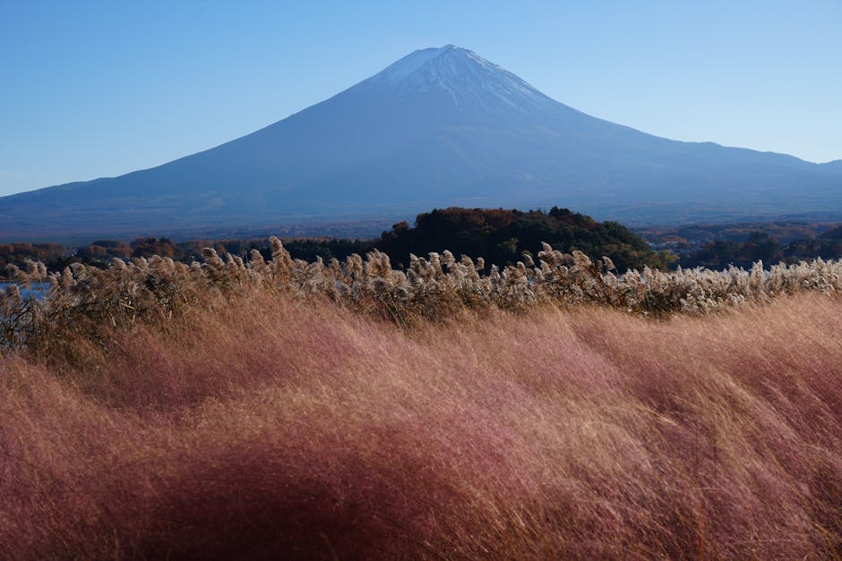
Autumn foliage turns the forests around all four lakes into blazing shades of red, orange, and gold — with Mt. Fuji often dusted with its first snow of the season. This is arguably the most photogenic season for the entire route, and the crowds are slightly thinner than cherry blossom season.
Winter (December – February)
The cleanest, clearest views of Mt. Fuji happen in winter when cold, dry air eliminates haze. Fuji wears its full snow cap and the sky is a deeper blue. However, Route 300 (Shojiko to Motosu) may be closed due to snow, and temperatures drop well below freezing. Pack accordingly, check road closures, and consider snow tires or chains if there’s been recent snowfall.
Summer (June – August)
Summer has the most clouds around Fuji, and the rainy season (tsuyu) in June brings persistent overcast skies. That said, July and August can produce stunning clear days, and the green forests are lush and beautiful. Kawaguchiko and the surrounding area are very popular in summer — weekends get crowded. Weekday visits are strongly recommended.
Frequently Asked Questions
Where can I rent a car for this route?
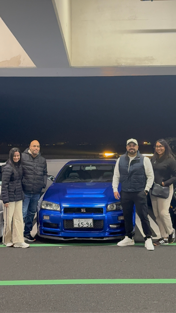
The most convenient starting point is Samurai Car Japan in Shibuya, Tokyo. They specialize in rentals for international visitors and are located right in central Tokyo, so you can check out of your hotel, grab your car, and be on the expressway within minutes. They offer standard rental cars as well as legendary JDM sports cars (GT-R, Supra, RX-7 — yes, really), have ETC cards included, provide English GPS navigation, and support International Driving Permits. It’s genuinely the smoothest way to start a road trip out of Tokyo. You can book at samuraicarjapanjdm.jp.
Do I need a special license to drive in Japan as a foreigner?
Yes — in addition to your home country driving license, you’ll need a valid International Driving Permit (IDP) issued under the 1949 Geneva Convention. You apply for this in your home country before traveling (AAA in the USA, AA or RAC in the UK, for example). A handful of countries have bilateral agreements with Japan — check the specific requirements for your nationality before your trip. Driving without the correct documentation can result in fines and complications with insurance claims.
Can I do this entire route in one day?
Yes — if you leave Tokyo early (6:30–7:00 AM) and keep your stops focused, you can cover all four lakes plus Chureito Pagoda, the Ropeway, and Aokigahara in a full day and be back in Shibuya by 7:00–8:00 PM. However, for a more relaxed and photographically rich experience, consider staying overnight near Lake Shojiko or Motosu and doing the final two lakes the next morning in the golden hour light.
What is the best lake for Mt. Fuji photography?
Each lake offers something different. Kawaguchiko is the easiest to photograph and has the most dramatic reflection shots, plus the famous Chureito Pagoda combo. Lake Motosu has the most iconic single view — the one on the 1,000-yen bill. Shojiko is the most intimate and undisturbed. For serious landscape photographers, we recommend shooting Kawaguchiko at sunrise, Chureito in the morning, and Motosu in the late afternoon or following dawn.
Are the roads around the Fuji Five Lakes easy to drive for first-timers in Japan?
Absolutely. The expressway portion is no different from driving on a motorway anywhere in the world (just remember to stay left). The national routes around the lakes are well-maintained, well-signed, and not particularly busy on weekdays. The one section requiring a little more care is Route 300 between Lake Shojiko and Lake Motosu, which has some narrow mountain road sections. Take it easy on the bends and you’ll be perfectly fine. Japanese drivers are generally courteous and patient — it’s a very pleasant country to drive in.
Why not elevate your journey with a legendary JDM experience?
Our Services:
- Self-Drive Rentals
- Guided Tours
- Drift Experiences
Please visit the dedicated page for more details.